When I began to plan for my 2025 retracing of the Lewis and Clark expedition, hauling an Airstream from Jefferson’s Virginia across the country to Astoria, Oregon, I realized I was planning a paradox.

Great Falls, Montana, July 5, 2025 — Thomas Jefferson’s Corps of Discovery made their 1803–06 journey almost entirely in boats. I was going to drive a pickup-trailer convoy along such river roads as exist from sea to shining sea. But the fact is, there are not so many places along the entire trail where you can see the rivers on which Lewis and Clark traveled: a short stretch here and there, a glimpse, a glance while driving over a narrow bridge. If you don’t actually get on the rivers, in what sense have you retraced their river journey? So I determined to get “on the water” as often as practicable.
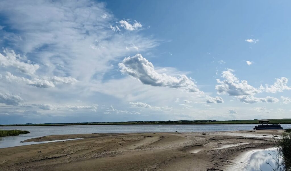
My first real chance to get on the water came in North Dakota. For many years, I have wanted to float the Missouri River upstream from Fort Yates at the bottom of North Dakota to Bismarck. Why? Because: a) I love North Dakota and aspire to be one of North Dakota’s best Lewis and Clark scholars (which is not that hard since I am really its only Lewis and Clark scholar); and b) because the massive Oahe Dam at Pierre, South Dakota, backs up the Missouri River for 231 miles to just south of Bismarck and therefore the only way you can see what Lewis and Clark saw is from the river … er, lake.
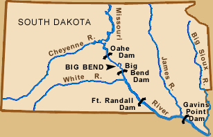
Notes: 1. Oahe Dam (dedicated 1962) is one of six gigantic rolled earth dams on the Missouri River between Fort Peck in eastern Montana and the bottom of South Dakota: Fort Peck, Montana; Garrison, North Dakota; Oahe, South Dakota; Big Bend, South Dakota; Fort Randall, South Dakota; and Gavins Point, South Dakota. This means that a total of 751 miles of the Mighty Missouri between Sioux City, Iowa, and the Judith River in Montana are now slackwater reservoirs. Alas. The Missouri is one of the claimants as “the most industrialized river in the United States,” along with the Columbia, the Colorado, and the Mississippi.
Note 2. Later this summer, I will float the Missouri in Montana twice in canoes, the upper Yellowstone on a raft, and the lowest reach of the Columbia on an excursion boat.
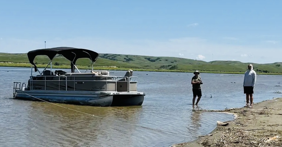
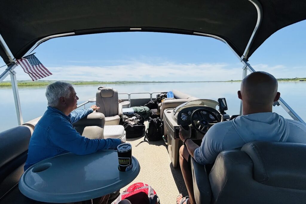
My audio editor, videographer, and now friend Nolan Johnson has a water-loving pal named Brian Jackson, and they know someone with a pontoon boat that doesn’t get much use. They arranged to borrow it for three days and Nolan’s dad Dennis — one of the nicest persons you will ever meet — agreed to drive us to the put-in boat ramp, resupply us with fuel and sundries along the way, and gather the bodies, dead or alive, at the take-out point in north Bismarck.
Dennis and Nolan picked me up more or less at the appointed time. They were half an hour late — no fault of Dennis! — But I have long since figured out that Nolan is always half an hour late, so I factored it in. Brian was ready when we appeared at his house in central Bismarck, holding a fishing rod in the manner of Huck Finn. We stopped to get a couple of bags of ice and made our way to the put-in point.
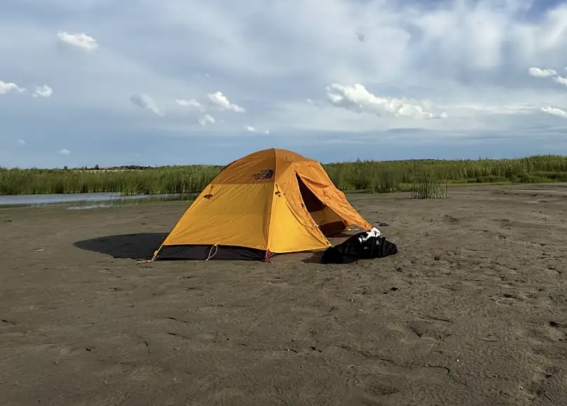
There were some tearful farewells at the Fort Rice boat ramp.
As Huck Finn puts it, “there warn’t nuthin’ to do now” but churn our way slowly up the Missouri River, against the 4–6 mph current, veering from one side of the reservoir to the other to get the Lewis and Clark photographs I wanted — the ostensible justification for the trip. Nolan and Brian were obsessed with hidden sandbars, even though the reservoir was about 20 feet deep most of the way. Over three days, there was only one sandbar incident. It amounted to nothing more than backtracking about a mile and taking a different channel up the river. It was not caused by human error, and it illustrated a frequent challenge to the Lewis and Clark expedition. Until the dams, the Missouri was a tough river to navigate. Some seasoned traveler from the nineteenth century said, “The problem of taking a boat trip on the Missouri River is you have to take the boat.” The river is full of snags, false channels, gravel and sand bars, dead trees that saw up and down with the current, banks that collapse, and a range of other impediments. As one local fisherman told me, “It ain’t the Erie Canal.”
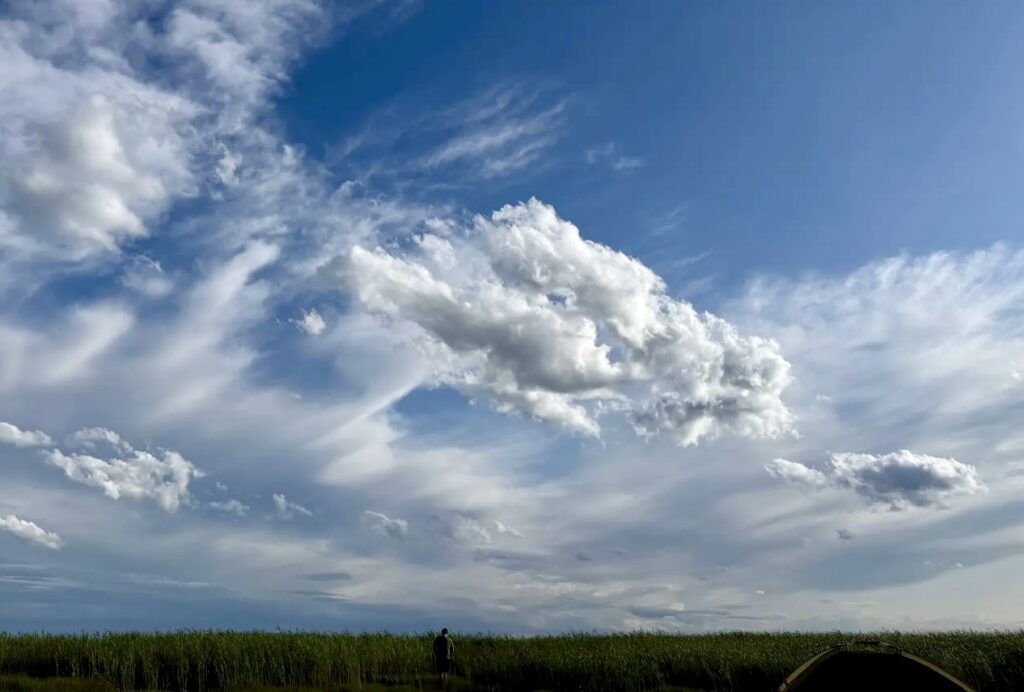
The weather was outstanding. At midday, 80 to 90 degrees Fahrenheit, with dead calm or modest winds. No rain. On day one, fabulously beautiful clouds. The boys made fun of me for wearing cargo pants and long-sleeved blue Listening to America work shirts. They wore shorts and T-shirts so the horseflies would have a chance to torment them. Every two minutes, one of them slapped his legs with angry violence, complained bitterly, and wondered why God had allowed the condor and the white rhinoceros to approach extinction but had done nothing useful about ticks and horseflies. I tried to explain the ecological interconnectedness of all things, that the tick is an important link in what the eighteenth century called “the great chain of being,” and that when humans decide to “fix” Nature, they usually wind up confirming the law of unintended consequences. I noticed that they ignored me after rolling their eyes a few times. This set a pattern for the trip. If they wanted to discuss the nuances of the movie Caddyshack or the odious Lewis and Clark-based film Almost Heroes, they lit up like boys on Christmas morning, but if I tried to explain the universe to them, they dozed off.
This may be a good place to describe my colleagues on the float. Brian is the CEO of a prosperous coffee company, Mighty Missouri Coffee, and he packed a generous supply. Naturally, he brought an elaborate AeroPress gizmo with him, and fussed over the morning coffee as if this were a Japanese tea ceremony. I can say with confidence that the sand in the coffee helped with digestion. Brian is a big strapping outdoorsman, handsome, with a world-class smile. He never complains (except about flies, sandbars, and the capacity of walleye to elude his fishing lures). Nolan is a brilliant videographer and a superb drone pilot who was once a talented high school and college athlete. One of them is 37, the other 38, and they have been inseparable friends from age seven or so. They “office” together in East Bismarck, where there are plenty of hijinks. Unfortunately, I soon learned that they have some kind of private discourse — complete with imaginary friends — that they revert to at nearly every opportunity — something about a guy named Joe of Brooklyn, complete with some rather lame NYC accents. They find themselves endlessly amusing and back home — during slack times in the coffee and digital video calendar — they produce private podcasts and video “shorts” that more or less define the term “prolonged adolescence.” When they got into that mode after dark, I slipped away to bed, but I could hear them chortling and high-fiving through the night.
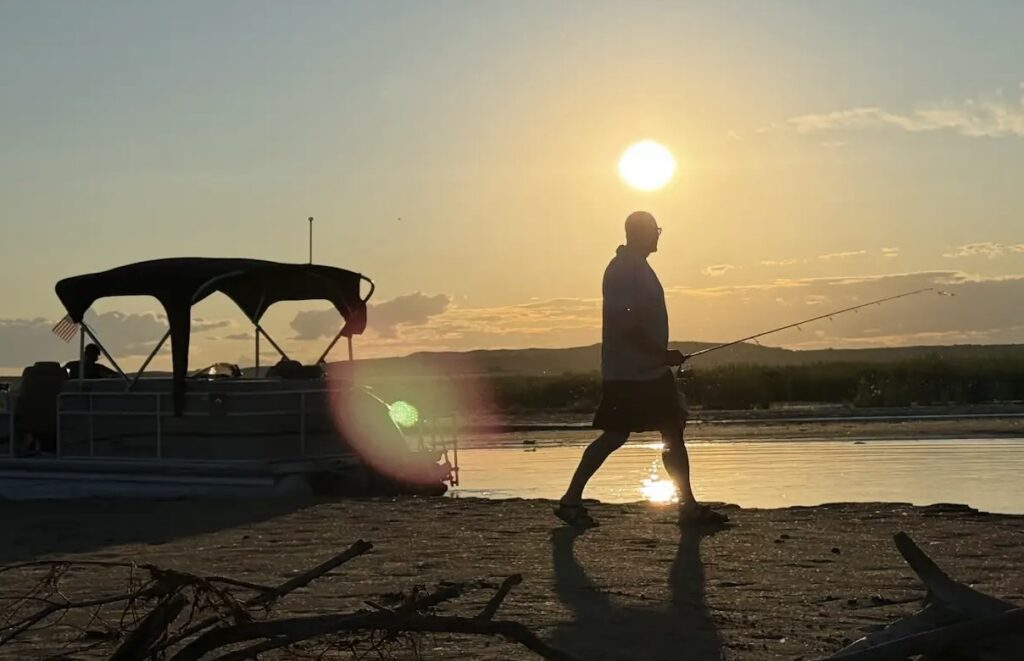
Brian has a reputation for being a great fisherman. This includes the claim that he is adept at spearfishing. When I heard that, I told him I could run a three-minute mile just to keep him honest. This time, he brought a regular old fishing rod and tackle, and he vowed that we’d be eating walleye fresh from the river at every meal. He even brought a box of Shore Lunch for garnish. I factored this in when I bought an unnecessarily large quantity of grocery food “just in case.” If I hadn’t, we’d have been eating our moccasins before day two. I don’t know how many times Brian cast his line into the great reservoir — famous for its fishery — but the only thing he reeled in in three days was a diminished reputation. You know the rest. He became increasingly determined (and eventually desperate), and he blamed his fishlessness on a dozen factors beyond his control. If he had had a grenade, he would have tossed it into the lake to bring up a few hundred walleyes to save face. So we dined on excellent beefsteaks, fried potatoes, eggs and bacon, cheeseburgers, trail mix, energy drinks, candy, and other delicacies that don’t require human skill. I brought them each a Pez dispenser for the same reason one purchases a Happy Meal for their children at McDonald’s. I do not exaggerate: I had to give them lessons in Pez dispenser reloading.
At the end of the first day, we scoured the starboard shoreline for a place to camp. The boys (I’m twice their age and infinitely less confident) make big claims about being river recreationists, so I decided to defer to them (by which I mean Brian) about campsites and such. He eased us into a little side bay about 7 p.m., and though it appeared to me to be a mosquito-infested swamp, he assured us that it was the best campsite available. I knew better, but I was not about to challenge his piloting. I do not exaggerate when I say that the sandbar on which we set up tents, ice chests, and camp chairs was so saturated with recent rains and a subsequent rise in the river that our feet sank no less than a quarter inch into the sand wherever we walked and at times up to the ankle bone. I made one slender little suggestion that we might press on to one of the 250,000 dryer places adjacent to the river, but I was assured that this was the best we could do.
I was reminded of the journal of George Bradley of the 1869 John Wesley Powell expedition down the Green and Colorado Rivers all the way from Green River, Wyoming, to the bottom of the Grand Canyon. Bradley, who kept a secret journal all the way, wrote: “The Major, as usual, has chosen the worst camping-ground possible. If I had a dog that would lie where my bed is made tonight, I would kill him and burn his collar and swear I never owned him.” For group harmony, I suppressed the urge to quote the passage to my fellow adventurers.
Each of us had a new two-man tent; I had it because it was time for a new one, and they — wait for it — had almost never slept in a tent before. Brian said perhaps three nights in three decades, Nolan just two. I put up my tent in five minutes. The stakes went into the sand as if it were butter, and little pools of water gathered around them. Brian took about fifteen minutes to set up his tent, and Nolan just under an hour. If I had known that they were rank amateurs, I would have asserted myself from the beginning, but the pecking order was already set, and I glumly prepared to sog it out through the night.
Because we were a little low on walleye, I cooked the first night: excellent ribeye steaks medium rare and fried potatoes, followed by some caramel walnut fudge I had purchased at one of those outdoor gear stores that also sell popcorn, fudge, and flavored coffee.
What Does Any Of This Have To Do With Lewis and Clark?
The Corps of Discovery reached the bottom of North Dakota on October 13, 1804. It was there that they conducted their last severe court martial: Private John Newman received 75 lashes (well laid on, as they phrased it) on a sandbar in the middle of the river. He had been throwing out “mutinous expressions.” Newman was also drummed out of the expedition’s ranks.
During their ascent from the Arikara nation’s earthlodge villages at the mouth of the Grand River just inside South Dakota, Lewis and Clark were traveling with an Arikara elder named Too Né, who told them about the things they were seeing on both sides of the river. Although at one point Clark — not known for his curiosity — wrote that “This Chief tells me of a number of their Treditions about Turtles, snakes, & and the power of a perticuler rock or Cave on the next river which informs of ever thing, none of those I think worth while mentioning,” he still reported an abundance of information about this stretch of the Missouri River that he could not possibly have known had Too Né not been traveling with them. Too Né gave them Native names for creeks and larger tributaries, pointed out abandoned Mandan villages, explained the annual antelope migration from the northernmost plains to the Black Hills region, explained the historic migration of the Cheyenne Natives from western Minnesota to Wyoming, and much more. It is worth noting that more often than not, Lewis and Clark were “conducted” through Missouri and Snake–Columbia River landscapes by Indigenous people recruited along the way. Sacagawea was with the expedition for 21 months. Old Toby of the Shoshone was with them for 50 full days. Twisted Hair and Tetoharsky of the Nez Perce were with them for many weeks.
My goal was to identify as many of the features mentioned in the journals as possible and photograph them. This segment of the expedition’s travels is not well known even in the Lewis and Clark community, because there are more dramatic episodes in Montana and farther west, and because the colossal reservoirs make it hard to appreciate the 1804 river journey. There is no bridge over the Missouri from Mobridge, South Dakota, to Bismarck, North Dakota, a distance of more than 125 miles. There are essentially no amenities along that entire stretch of the Missouri, unless you want to gamble at Prairie Knights Casino on the Standing Rock Indian Reservation. In other words, besides William Least Heat-Moon in his 1999 book River Horse: The Logbook of a Boat Across America, I am likely to be the first person to try to link up the geography of this lonely stretch of country to the journals of Lewis and Clark.
Day Two:
When I unzipped myself out of my tent and began to slip and slide my way to the camp kitchen, Brian was brewing coffee. He’d been up for a while. He took a cold bath in the swamp, so Nolan and I felt we had to do so, too. I cooked bacon and scrambled eggs with cheese, and Nolan and Brian got into a friendly squabble about the virtue (or not) of frying Cloverdale tangy summer sausage as a breakfast treat.
Our second day was outstanding. Inevitably, we passed a dozen better — even ideal — campsites within two miles of the dismal swamp. We stopped mid-morning on a long sandbar. Nolan lofted his drone to get stunning images of the river (er … lake) and Brian went a-fishin’. At one point, he had waded more than half a mile away to a cluster of some good old boy local fishermen. He offered them a lifetime subscription to Mighty Missouri Coffee if they would only let him put one small walleye on his hook so he could come back to us looking like Brad Pitt in that famous scene in A River Runs Through It.
One really good thing about Brian — there are many. When he finds an “artifact,” whether it is a bit of a bison skeleton or a Native American object below a river bank, he gets down on his knees to appreciate it for a while and then leaves it precisely where it is. This almost made me forget the first night swamp camp.
We passed the mouth of Fish Creek. We passed the mouth of the Cannonball River, named for the sandstone concretions it releases from the river banks. They are usually spheroid, the size of volleyballs, basketballs, or even beach balls. They are like sandstone pearls somehow formed by sedimentary pressures. North Dakotans collect them, haul them home, and display them on the edge of their driveways, where they lose their mojo (and significance) because they were removed from the natural landscape in which they had meaning. Lewis and Clark passed the mouth of the Cannonball River on October 18, 1804. They, too, appropriated a heavy concretion to replace the keelboat’s anchor that had been lost in a river accident in South Dakota.
We moved slowly upriver. It was summertime, and the livin’ was easy. I read the journals — silently, because they were busy gazing lovingly at their smartphones. We used all the databases we had to identify bluffs, buttes, creeks, and river oxbows. From a Lewis and Clark perspective, the journey was turning out to be a complete success. I was able to match Clark’s descriptions of the terrain with features in the landscape; this would have been nearly impossible from the roads that attempt to follow the sinuous shoreline.
This night we camped on a fabulous and dry sandbar island in the middle of the river. Lewis and Clark often chose sandbar islands for campsites as a security precaution. We had another great meal — jumbo cheeseburgers, cowboy beans, and individually appropriate beverages. I had brought along some Roman candles and large bottle rockets I had found somewhere in the far recesses of my garage. We had a slightly premature celebration of the Fourth of July. The stars were magnificent. The lads stayed up late doing their shtick in some debased Cockney, amusing themselves to death.
In the middle of the night, Nolan had a Jimmy Carter moment. We had noticed a large number of beaver lodges against the banks of the river. After dark, one pesky beaver swam around slapping its tail on the water, moving in front of the pontoon and then behind it, across the river, and then back again. At some point, Nolan had the paranoid thought that the angry beaver was going to bite through the rope that anchored us to the shore, and we’d never see the pontoon again until the wreckage washed up below New Orleans. So he took his flashlight and mounted guard for a while. He said he was afraid that the beaver would jump on shore and attack him like the killer rabbit that tried to assassinate President Carter on April 20, 1979. Lewis and Clark fought off grizzly bears, wolves, rampaging buffalo, and (in one late instance) hostile Natives, and they ate beaver tail as a great delicacy. But there is no mention in the thirteen volumes of expedition journals of a beaver attack on the men. I tried to imagine a beaver so evil that it would chew off an anchor rope. I could only conclude that even if Nolan had brought his drone, it is not clear that he would have lasted long on the Lewis and Clark expedition. In the morning, when I unzipped my tent flap while Brian used his elaborate gizmo to brew more coffee, Nolan appeared looking like the beaver had not bitten him but half-drowned him. He said he didn’t want to talk about it, and we left it at that.
Day Three:
Alas, this was our last day on the river. What amazed me most and delighted me most was that as the reservoir was reaching its northernmost reach, the Missouri River was beginning to reclaim its dignity. We had reached the last of the slackwater. The river narrowed, became more shallow, braided itself a bit, and threw up some sandbars. Now, finally, we were beginning to approximate the Corps of Discovery’s river journey, except that:
— We were using a 175 hp engine to propel us upriver, and so far as I know, none of us ever broke a sweat in three days. Those water marks on my shirt were legacies from the swamp camp.
— We did not have to go hunting on shore to kill food for dinner.
— We had smartphones that delivered instantaneous data that William Clark would have sold his soul to obtain so effortlessly.
— Nolan’s dad, Dennis, was on call if anyone got a blister or an owie.
— We had packs of Wet Ones.
— We would not run into a grizzly bear, even though Lewis and Clark’s man Pierre Cruzatte blundered into one just south of Bismarck on October 20, 1804, the first of scores of grizzly encounters, a few of them nearly lethal.
— We had a plethora of maps (historic and modern), atlases, guidebooks, and both physical and electronic copies of the expedition journals, plus an app (onX) that told us temperature, depth of river, where the thalweg was, who owned the riverside property, where we were legally allowed to camp, what we could expect by way of precipitation, how to get a fishing license (but alas, not how to catch a fish!), fun facts about rivers, the volume of water at Sioux City and Natchez, the annual navigation volume on the lower Missouri, and how to gut a marlin.
— We knew what to expect around the next bend.
— And we would not have an encounter with Native Americans, friendly or otherwise.
Beyond that, we were authentic American explorers.
I got the photographs I wanted. I enjoyed my two young friends immensely. We had perfect weather, and though I am a lifelong North Dakotan, I saw a whole and historically significant swath of it for the first time.
As we approached Bismarck, we could see the bell tower of the University of Mary and the upper floors of the 21-story North Dakota Capitol. We passed the mouth of the Heart River just below old Fort Lincoln of Custer fame. The Heart is named for its position at the heart of the Mandan Indian world. Once, there were nine or thirteen earthlodge villages clustered around the mouth of the Heart. That was before the first great smallpox epidemic that reduced the population of the ingenious Mandan from 20,000 to about 150. (The second wave in 1837 would reduce the entire Mandan population to 145.) Dennis was waiting on the dock. I told him: a) that I had survived the trip; and b) that there were things about the journey I would only tell him if we were throwing back shots at a biker bar.
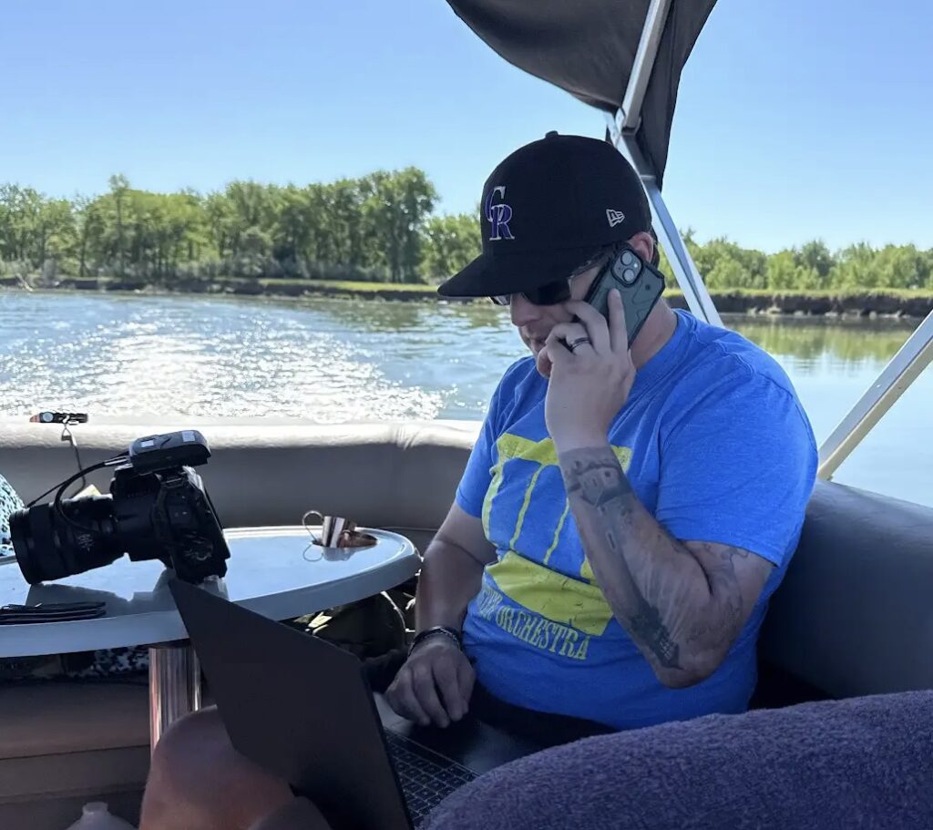
One last note, about generational change and technology. I brought Clark’s maps. I brought the gorgeous 1895 Missouri River Commission maps. I brought volume one of Martin Plamondon’s three-volume Lewis and Clark Trail Maps that shows the river as Lewis and Clark ascended it, and the outlines of the reservoirs that have now drowned the Missouri. I brought a very detailed North Dakota gazetteer. I had expected that they would delight in this array of cartographical information and study the maps closely, all three days. But it became immediately clear that they were not interested in these resources. They were fixated on their 3-by-6-inch smartphones and such resources as they provided. I was crestfallen, but I recognize that I’m an old fuddy-duddy and they are hip, young, connected, and — may I say — addicted to smart technology.
I tried for three days to stay off my iPhone entirely. They were seldom more than a few minutes from screentime. No point in wringing one’s hands. These young men had more immediate access to vital information — weather fronts, temperature, exact GPS location, releases from the dams, etc. — than I did with my old-school tools. They have never not known a digital world. When I took notes on my clipboard in the presence of these digital whippersnappers, it felt like I was using cuneiform.
We are planning our next excursion, between Bismarck and Garrison, North Dakota, where Lake Sakakawea (a reservoir) yields for 90 miles to something that could, without hopeless exaggeration, be regarded as the Missouri River.
I’m going to bring fishing gear. Heck, I can catch as many fish as Brian.