2025 ROADTRIP — RETRACING THE LEWIS AND CLARK TRAIL

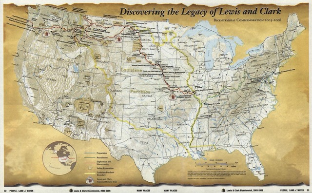
Kicking off on May 6th at Thomas Jefferson’s Poplar Forest in Lynchburg, Virginia, Clay set out to retrace Lewis and Clark’s celebrated 1804-1806 expedition across the continent. Clay will trace the Lewis and Clark expedition from Virginia, where it was conceived in the imagination of Thomas Jefferson, all the way down the Ohio River, up the Mississippi and Missouri, over the Bitterroot Mountains, down the Clearwater, Snake, and Columbia rivers — and back again.

Traveling in a 23-foot Airstream, Clay’s expedition is a central part of LTA’s big initiative to take the pulse of America as it approaches its 250th birthday. You can follow Clay’s Lewis and Clark adventure in the stories and videos linked below and on the LTA Facebook site. Also, subscribe to our newsletter.

Clay Jenkinson at the confluence of the Mississippi and Missouri Rivers. (Photo by Nolan Johnson)

My Year in Review

Last week, I reviewed the year 2025 by way of Time magazine’s Year in Review issue. Today I want to review my year as the traveling editor of Listening to America.
Natalia (Nat) and Michael (Mikey), two British school teachers, are currently on holiday in the US. They are canoeing over 3000 miles from Three Forks, Montana, down the Mississippi to New Orleans.
Featured on our podcast last week, LTA followers have asked for an update in the saga of Nat and Mikey, a couple of Brits currently paddling from Montana to New Orleans.
The Meriwether Lewis monument commemorates the gravesite of the co-captain of the Lewis and Clark Expedition along the Natchez Trace Parkway in Tennessee.
Completing a year following the Lewis and Clark Trail, Clay visits the lonely gravesite where the 35-year-old Meriwether Lewis is buried.
Lewis and Clark National Historic Trail marker.
After decades of close study and a year following their trail, Clay remains dogged by the many unknowables surrounding the famous American expedition.
A statute of Lewis and Clark and the expedition's
How did the Lewis and Clark Expedition stack up against the model for the classic journey? Clay makes his assessment.
Clay and friends enjoy a late summer afternoon on a remote section of the Missouri River in central Montana. (Photo Bryan Hall)

Four Perfect Days

Clay and friends are just off four perfect days canoeing remote sections of the Missouri River in central Montana.
Airstream and truck
Clay assesses the good and bad as he wraps up his second season traveling America's byways in his 23' Airstream.
Fort Peck Dam. The U.S. Army Corps of Engineers has operated the dam since 1940. Stretching across the upper Missouri River in northeastern Montana, it is the furthest upstream of six dams and reservoir projects built on the mainstem of the upper Missouri River. (U.S. Army Corps of Engineers)
The Missouri was a wild, free-flowing river when Lewis and Clark began their epic western journey in 1804. Today, much of that river is a series of reservoirs.
Cannon Beach on the Oregon Coast. It was near here in early 1806 that Sacagawea insisted she be allowed to join the expedition team going to see a whale that had washed up on the shore.

Sacagawea and the Blue Whale

Sacagawea’s insistence that she be allowed to join the reconnaissance team heading to see the great beached whale is one of the rarest instances in the entire Lewis and Clark journey where we hear her voice.
Earlier this week, Clay made a pilgrimage to the site called Dismal Nitch, where Lewis and Clark were marooned for six miserable days in November 1805. There is a somewhat confusing academic debate about which of the three or four identical nitches within a two-mile stretch of the Columbia River estuary is the actual, official, certified Dismal Nitch. This seems to have sent Clay into a bit of a spin.

Ode to Dismal Nitch

Has our friend Clay Jenkinson been too long alone on the Lewis and Clark Trail?
Tagged under: