Day Two: Saturday; Boulder, Utah and the Escalante River.

This is the third in a series of dispatches from Clay Jenkinson chronicling his recent journey with two compatriots following the Colorado River and neighboring region. The day was spent in and around Boulder, Utah (population, 248; elevation 6700’). The two-week expedition explored the state of water, or the absence of it, in the West.

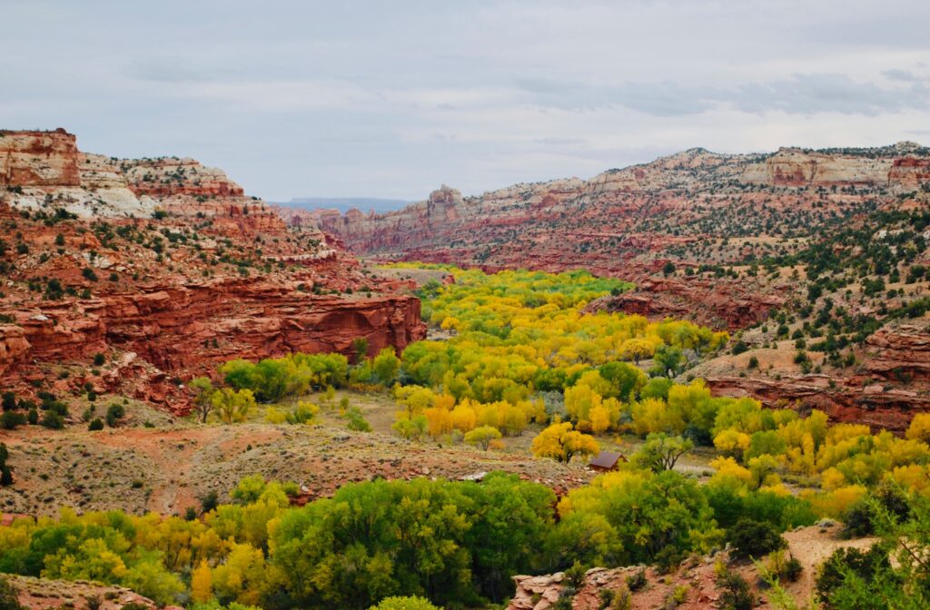
I conducted an online humanities class by Zoom Saturday morning. Then we ventured out to see the near countryside and to talk logistics. Dennis brought along a map that we kept leaving in the car. That morning he said, “There’s a coffeehouse not far from here where I thought we could have lunch and spread out the maps.” I don’t know what I had in mind, but what I imagined was closer to Starbucks (in a run-down adobe building) than where he took me. Kiva Koffeehouse was the name of the place. It’s on a small mesa top above the Escalante River on Utah highway 12. It must be on the list of the top 10 “most beautiful coffee houses in the world.” We ordered locally grown food and drank the off-brand sodas and waters you get in such places, where asking for a Diet Coke gets you a condescending look. Exquisite soup. This would become a minor revelation of our journey. All sorts of hidden gem shops, restaurants, and lodges scattered over the immense plateau. It’s not like Aspen or Sedona or Jackson Hole where there are superb amenities all the way up and all the way down the streets. Out here it’s Subway and Dairy Queen (if you are lucky) most everywhere, and then a marvelous little hole in the wall bistro with a five-star rating in some village that could not by itself possibly support it. Such places live for the tourists, often enough from Europe or Asia.
After lunch we stopped at a turnoff at the upper reach of Escalante River. John Wesley Powell’s 1872 survey expedition named the river to honor Father Escalante — a leader of the 1776 Dominguez-Escalante Expedition that searched for a trade route from Santa Fe, New Mexico, to Monterey, California. We walked a hundred yards along the river, which was already flowing in a lovely way, apparently aware that it’s a wet year, but not yet doing any serious eroding. A lot of our talk is about making sense of the canyons, the cliffs, the mesas, the isolated mountain ranges, the creeks and washes and rivulets and springs. We’ve been reading about these things all our lives, and we have individually spent a fair amount of time up and down the Colorado basin, but the density and the ubiquity of dramatic landscape features weigh on us like a burden. Thomas Jefferson thought the whole West was likely to be an extension of the Ohio Valley, well-watered and rolling terrain. Imagine what he might have thought in seeing the confluence of the Green and Colorado in Canyonlands National Park. At Virginia’s impressive but modest Natural Bridge, Jefferson got a “violent head ache” when he stood on top of the arch. He had to get down on his hands and knees to “peep over the parapet.” There is a reason that the West has such a grip on the world’s imagination — Europeans cannot get enough of it. The West is not just one epitome of America, but also the magical platform on which the frontier dynamics unfolded, with gunfights at high noon, rustlers and vigilance committees, saloon girls, card games, lonely settlers out beyond Dodge City, women going mad in tiny clapboard huts during the endless Dakota winters, and Native Americans who resisted the invasion and the confiscations, but with inherent nobility. In other words, this is the epicenter of one of the world’s most potent modern myths: the Myth of the American Frontier.
For dinner, we ate exquisite locally sourced beefsteaks, and wine from very far away.
Editor’s Note: You can track Clay’s dispatches on this Colorado River Journey by following the links from his route and itinerary below. You can also keep up with all LTA’s dispatches, essays, photos, and podcasts on this topic through the tab “Water in the West.” This is one of many ongoing road trips at the heart of Listening to America. Our mission is to “light out for the territories,” traveling less visited byways and taking time to see this immense, extraordinary country with fresh eyes while listening to the many voices of America’s past, present, and future.
Water in the West — Routes and Itinerary
- Introduction: A Colorado River Journey, The Trek Begins.
- Day One, Friday: I-70 Vail to Green River; Utah 24 to Torrey; Utah 12 to Boulder, Utah.
- Day Two, Saturday: Boulder, Utah.
- Day Three, Sunday: Utah 12 to Torrey; Utah 24 to Hanksville; Utah 95 to Natural Bridges National Monument; Utah 261 to Mexican Hat; U.S. 163 to Bluff; Utah 162 to Aneth; Indian Route 5068/Arizona County Road G to Cortez.
- Day Four, Monday: Crow Canyon Archaeological Center, Cortez, Colorado.
- Day Five, Tuesday: Colorado 160/491 to Chimney Rock; Colorado 160 to Teec Nos Pos; Colorado 160 to Mexican Water; U.S. 191 Tsaile; Arizona 64 to Chinle.
- Day Six, Wednesday: Canyon de Chelly; U.S. 191 to Burnside; Arizona 264 to Second Mesa.
- Day Seven, Thursday: Hopi Cultural Center; Arizona 264 to Tuba City; U.S. 160 to U.S. 89; U.S. 89 to Bitter Springs; U.S. 89A to Marble Canyon.
- Day Eight, Friday: U.S. 89A to Bitter Springs; U.S. 89 to Page, Arizona.
- Day Nine, Saturday: Lake Powell; U.S. 89 to Kanab.
- Days 10 & 11, Sunday/Monday: U.S. 89 to Utah 20; Utah 20 to I-15; I-15 to Salt Lake City.
- Days 12 & 13, Tuesday/Wednesday: Salt Lake City.
- Reflections on A Colorado River Journey.
