The Missouri was a wild, free-flowing river when Lewis and Clark began their epic western journey in 1804. Today, much of that river is a series of reservoirs.
The 1804-1806 Lewis and Clark expedition was a river journey. President Jefferson instructed his protégé and personal secretary Meriwether Lewis to ascend the Missouri River to its source, climb up and over the Rocky Mountains, and descend the rivers of the Columbia basin all the way to the Pacific Ocean. Lewis commissioned a 55-foot keelboat in Pittsburgh (the putative source of the Ohio River), and floated (soon with William Clark) down to its confluence with the Mississippi (at today’s Cairo, Illinois). Then they floated 190 miles up the Mississippi River to St. Louis. After a winter’s layover at a makeshift compound they called Camp Wood on the Illinois side of the river, the expedition struggled its way up the Missouri to today’s North Dakota (Fort Mandan), where they spent a cold but snug winter. In the spring, the keelboat was sent back downriver, and the expedition proceeded on with “six small canoes and two large pirogues.”
In those days, rivers were roads, and roads were rivers. The best way to get across the continent in 1804 was along waterways. Lewis and Clark carried a comprehensive set of instructions, a wide-ranging Enlightenment agenda. However, central to Jefferson’s objectives was for the expedition to discover the “most direct & practicable water communication across this continent, for the purposes of commerce.”
The only serious impediment on the Ohio River was the falls at Louisville, Kentucky. The Mississippi was wide open. The Missouri — as Lewis noted with some astonishment in southwestern Montana — was navigable nearly to its source, with only the five cataracts at today’s Great Falls requiring a portage of the expedition’s tons of baggage. Farther west, the Bitterroot Mountains proved to be the chokepoint of the journey — both going out and coming back. But once the expedition found floatable waters of the Columbia system at today’s Orofino, Idaho, and trees big enough to fashion dugout canoes, they were able to descend the Clearwater, Snake, and Columbia (at breakneck speed) without portaging until they reached Celilo Falls and the Cascades. The Clearwater, Snake, and Columbia were a wild ride. The expedition reached the Pacific Ocean sometime between November 7 and November 15, 1805, depending on definitions of what constitutes the mouth of a river.
And then, a few months later, they traveled all the way back. The return journey must have been a difficult time for everyone on the expedition. They were half-destitute of trade goods, they knew now the rigors ahead of them, and they were all just eager to get home — well, all but Private John Colter.
That Was Then
If one wanted to float the Lewis and Clark rivers today, there would be many frustrating impediments. There are a total of 92,000 dams in the United States, with 1,920 designated as major dams. A significant number of them are on the Missouri, Snake, Clearwater, and Columbia rivers.
In the interest of relative brevity, let’s concentrate on what Lewis called “the mighty and heretofore deemed endless Missouri River.” The float trip would start pretty well. If you began your journey at St. Louis, you’d be able to float unobstructed all the way to Yankton, South Dakota, a distance of 811 river miles. Then the difficulties begin.
Impediment One:
At Yankton, you would butt up against Gavins Point Dam, built between 1952 and 1957, backing up a reservoir called Lewis and Clark Lake, 25 miles long. Its maximum depth is 45 feet.
Impediment Two:
Fort Randall Dam is located at river mile 880, just 44 miles upstream from the backwater of Lewis and Clark Lake. The reservoir it creates is 107 miles long, with a maximum depth of 140 feet. It was built between 1946 and 1953. The dam created Lake Francis Case, named after a 35-year member of Congress from South Dakota — the last waters of Lake Francis Case butt right up to the spillway of Big Bend Dam.
Impediment Three:
Begun in 1959 and completed in 1963, Big Bend Dam, near Thompson, South Dakota, is 80 miles long, with a maximum depth of 78 feet. It backs up the Missouri River to within just eleven miles of Oahe Dam at Pierre. The reservoir is named Lake Sharpe in honor of the 17th Governor of South Dakota, Merrill Q. Sharpe.
Impediment Four:
South Dakota’s Lake Oahe is a full 231 miles long, backed up by the Oahe Dam, which was begun in 1948 and finally completed in 1962. It’s the fourth-largest man-made reservoir in the United States. Its maximum depth is 205 feet. President John F. Kennedy traveled to Pierre, South Dakota, to dedicate the dam on August 17, 1962. (I floated about 50 miles of Oahe in July.) Lake Oahe finally plays out just south of Bismarck, North Dakota.
The 87 miles of the flowing Missouri between Bismarck and Garrison Dam are “free” in a very loose sense of the word. This stretch is heavily rip-rapped by the U.S. Army Corps of Engineers to prevent the river from overflowing its banks, as it is naturally supposed to do and once did. Because Garrison Dam is a silt trap, the water below the dam is cooler and clearer than the pre-dam Missouri. For the first 10 miles above Bismarck, the west bank is fairly densely occupied by luxury homes. There are some truly lovely stretches of the river in those 87 miles. Unfortunately, most of the land on both sides of the river is privately owned, some of which is farmed, and thus off-limits to land-based recreation.
Impediment Five:
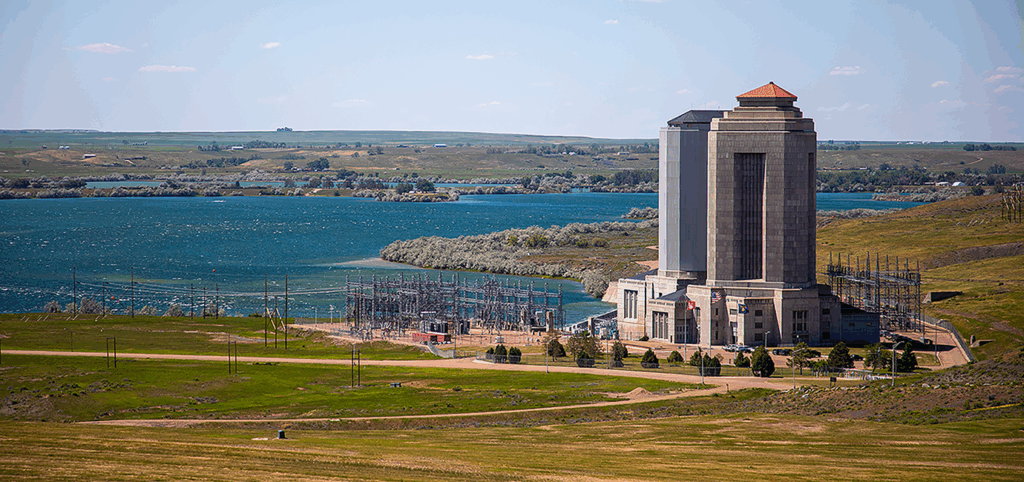
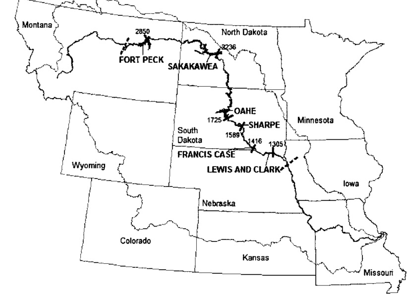
Garrison Dam is the fifth-largest earthen dam in the world. Construction began in 1947 and was finished by 1953. Its reservoir, Lake Sakakawea, is 177 miles long. The reservoir was named for the Shoshone-Hidatsa woman who traveled with the Lewis and Clark expedition from April 1805 until mid-August 1806.
Fortunately, after Lake Sakakawea plays out, the Missouri River is permitted to run something like a live river between Fort Peck, Montana, and the confluence of the Missouri and Yellowstone at Williston, North Dakota. That’s a long stretch: about 250 miles. The region is so isolated and remote from anything else, however, that it has never emerged as a recreational attraction.
Impediment Six:
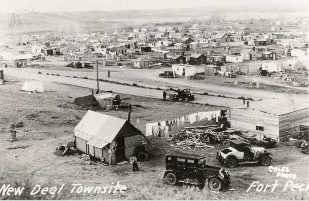
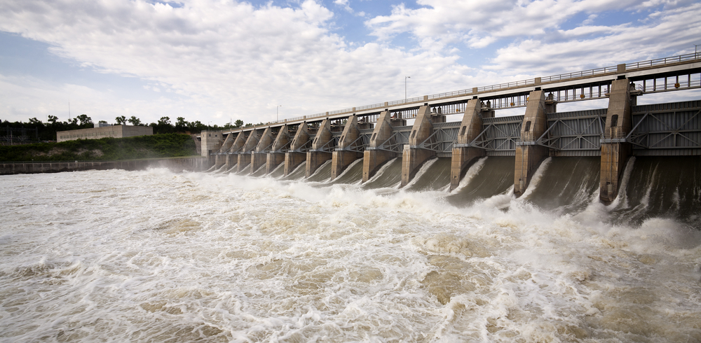
The first of the great dams on the Missouri River was a New Deal project. Fort Peck Dam was built between 1934 and 1940 in the depths of the greatest economic crisis and the worst drought in American history. Fort Peck Reservoir is 134 miles long. Maximum depth 220 feet. The promise of the New Deal was so perfectly embodied in the massive public works project that Life magazine, in its very first issue, November 23, 1936, ran a cover story on Fort Peck, featuring extraordinary photographs taken by Margaret Bourke-White, one of the great photographers of the twentieth century. Her cover photo of the dam’s giant white concrete buttresses looks like a Depression fortress against “fear itself.” Ivan Doig’s 1996 novel Bucking the Sun is an account of a family that leaves their desiccated alfalfa fields to find work at the dam site.
So. At least half of the two Dakotas’ contingent of the Missouri River is now under tens and sometimes hundreds of feet of reservoir water. A flotilla would have to portage around all six of those massive dams, none of which have locks, and for about half of the journey from St. Louis, it would be a lake rather than a river experience.

Free at Last
Suppose you could get through all that slackwater between the bottom of South Dakota and east central Montana, when Fort Peck Reservoir finally plays out north of Mosby and south of Malta, Montana. In that case, you finally get to something resembling the pre-industrial Missouri River. The Missouri between James Kipp Recreation Area and Fort Benton is, without question, the best of what’s left of the Missouri. That 200-mile segment includes the fabled White Cliffs section of the Missouri (Meriwether Lewis’ “scenes of visionary enchantment”) and the Missouri Breaks, a remote badlandsy reach of the river that flows through one of the least densely populated regions of the United States. This is the Missouri River most loved by Lewis and Clark types. (I’ve floated it 25 times, each experience slightly different, proof positive that the pre-Socratic philosopher Heraclitus was right when he declared that “no man steps into the same river twice.”)
Impediment Seven:
At the falls of the Missouri, Lewis and Clark were forced to conduct an 18½ mile portage with their tens of thousands of pounds of baggage and gear. There are five cataracts at Great Falls: Black Eagle Falls, Colter Falls, Rainbow Falls, Crooked Falls, and the Great Falls themselves. It took the expedition a month to get around all of these impediments.
Beyond that, there are a few Missouri River dams of the second rank: Holter (25 miles long), Hauser Dam (25 miles), Canyon Ferry (30), and Toston (just a couple of miles).
If you start to add all of these dams and rip raps up, you can see why the Missouri is always on the short list for “the most industrially compromised river in America.” There are 14 major dams between Three Forks, Montana, and St. Louis. If we agree that the Missouri is approximately 2,540 miles long, and compare that which can be said to be “free flowing” with that which has been transformed into a series of water storage containers, the result is daunting, and for many, heartbreaking.
According to the United States Geological Survey (USGS), a total of 1,179 miles of the Missouri River are impounded (i.e., reservoirs), and 1,361 miles are “free flowing.” In other words, nearly half (46%) of the Missouri River between St. Louis and Three Forks, Montana, consists of slackwater. Read Gary Moulton’s masterful, comprehensive edition of the Journals of the Lewis and Clark Expedition, including all of its thousands of annotations. You’ll find endless footnotes like these: “In McKenzie County, North Dakota, a site now under Garrison Reservoir.” “Sunday Island was still on the map in the 1890s; it would not be under Garrison Reservoir.” “The area is now inundated by Oahe Reservoir.” “The two sites are in Phillips County, Montana, and are now inundated by Fort Peck Reservoir.”
In my own North Dakota, for example, every Lewis and Clark site between the South Dakota border and Bismarck has been inundated (95 miles). That includes everything between October 13 and October 21, 1804. Between Bismarck and Garrison Dam, there are 87 “free-flowing” miles of the Missouri. Garrison Dam’s massive Lake Sakakawea (177 miles) extends right up to the Montana border, thus drowning every Lewis and Clark site from between April 10 and April 27, 1805, and between August 3 and August 13, 1806 (on the return journey). In other words, of the 423 total Missouri River miles within the state of North Dakota, 336 are impounded under Lakes Oahe and Sakakawea. That’s 79%. The industrialization of the Missouri River drowned the mouth of the sublime Little Missouri River near Twin Buttes, North Dakota (April 13, 1805, outward bound), and the site where Meriwether Lewis was accidentally shot in the buttocks (August 11, 1806, return journey).
The Real Tragedy
This matters greatly to me, but I freely acknowledge that those inundations are no big deal in the grand scheme of things. But ask a member of the Lakota Nation, or the Mandan, Hidatsa, and Arikara Nation, to assess the impact of Oahe and Garrison Dams, and you enter the realm of a holocaust. In the mid-twentieth century, those Native Americans, indigenous here, sovereign on their homelands, and full citizens of the United States, were flooded out and flooded back from the Missouri River by the United States government and the U.S. Army Corps of Engineers. They were not consulted. They were not at the table. Their views, rights, and ways were not represented in the faraway rectilinear rooms where American decisions are made. They were minimally compensated. They were merely notified after the decisions were laid in concrete. During the great dam building era of American history between 1920-1976 (when Jimmy Carter was elected to the presidency), fueled by the gargantuan economic power of “the American Century,” drunk on concrete and steel after the massive industrial success of World War II (the Manhattan Project, the Burma Road, the 8,500-foot B-29 runway at Tinian in the Marianna Islands, the nearly miraculous pace of airplane manufacturing at Boeing), and enjoying more abundant natural resources than any other country except Russia, the United States built Interstate highways, world-class bridges, a myriad of skyscrapers, and cyclopean dams! Hoover 1936, Grand Coulee 1942, Shasta 1945, Davis 1950, Chief Joseph 1958, Glen Canyon 1963, Flaming Gorge 1964, John Day 1971. Fort Peck. Gavins Point. Fort Randall. Big Bend. Oahe. Garrison.

The Lakota elder and writer Elizabeth Cook-Lynn has said that the damming of the Missouri River in the Dakotas “cut the spiritual artery of the Lakota people.” As Garrison Dam backed up right through the Fort Berthold Indian Reservation in central North Dakota, fully 85% of the Mandan, Hidatsa, and Arikara people were forcibly removed from their fertile and economically sustaining river bottomlands and relocated up onto the windswept plains. Nine towns were inundated, and 94% of the tribes’ agricultural lands. Although the Mandan, Hidatsa, Lakota, and Arikara are resilient and persevering people, they have never fully recovered from the cold-blooded damming of their river. If you want to read about this sorry episode in American history, I suggest Paul VanDevelder’s Coyote Warrior.
In the face of that 20th-century catastrophe, a campsite visited for a day or two by a pack of pale bearded men from somewhere far away 230 years ago approaches the border of frivolity.
I’m no hydrologist, but I do know that the six main stem dams on the Missouri River were both-and political “compromise” that lumped into one swollen Missouri River Development project almost everything the two rival federal agencies, the U.S. Bureau of Reclamation and the U.S. Corps of Engineers, had each individually envisioned to transform the Missouri Basin. In other words, we dammed the Missouri River much more than was necessary. I know a superb Missouri River historian who believes one or even two of the six mainstem dams could be removed without significant loss of flood control, including (he suggests) Garrison Dam, the cause of the Mandan-Hidatsa-Arikara tragedy.
We now live in a post-industrial era in which dam removal is finally a realistic possibility, especially out where the salmon population has collapsed thanks to giant dams on the Snake and Columbia Rivers, and where (we now know) dam removal would almost immediately begin to restore those salmon runs. There is talk about dismantling the Glen Canyon Dam on the Colorado River. There is a significant and growing Rivers Have Rights movement worldwide. It is easy to imagine selective de-damming of the Missouri River, but it is harder to believe that it is politically possible. Not yet.
For us Lewis and Clark types, the appeal of the 1804-1806 expedition is anchored in the romance of American rivers. For indigenous peoples of the continent, living rivers are not a metaphor. Countless billboards, murals, bumper stickers, water towers, and protest signs in “Indian Country” say simply: “Water is Life.”

Follow Clay and the LTA Airstream as he retraces the famous Lewis & Clark Trail from 1804-1806 across the continent. This 2025 expedition is a central part of LTA’s big initiative to explore the country and take the pulse of America as it approaches its 250th birthday. Be sure to follow Clay’s adventures here and on Facebook — and subscribe to our newsletter.